Tools4MSP Geoplatform - legacy/deprecated version
Feb. 10, 2023, 11:25 a.m.
Cumulative Impact Assesment
In the last decade cumulative impact (CI) analysis has become an essential tool for the geospatial identification of highly impacted environmental components by marine anthropogenic uses. Since the application of Halpern’s CI analysis on global scale in 2008 (Halpern et al., 2008), several studies around the world have been investigating CI patterns on sea basin level, such as in the Mediterranean Sea (Micheli et al., 2013), Baltic Sea (Korpinen et al., 2012) or North Sea (Andersen et al., 2013).
Aim
Aim of the tool is to support the MSP process under an Ecosystem-Based Approach (EBA) by assessing the potential cumulative impacts of maritime activities on the marine environment.
The CI assessment tool was developed during the ADRIPLAN project (http://adriplan.eu). It is the core tool of the Tools4MSP, an open source geopython library. The tool was tested for the Adriatic-Ionian sub-basin, but can be deployed to any research area around the globe.

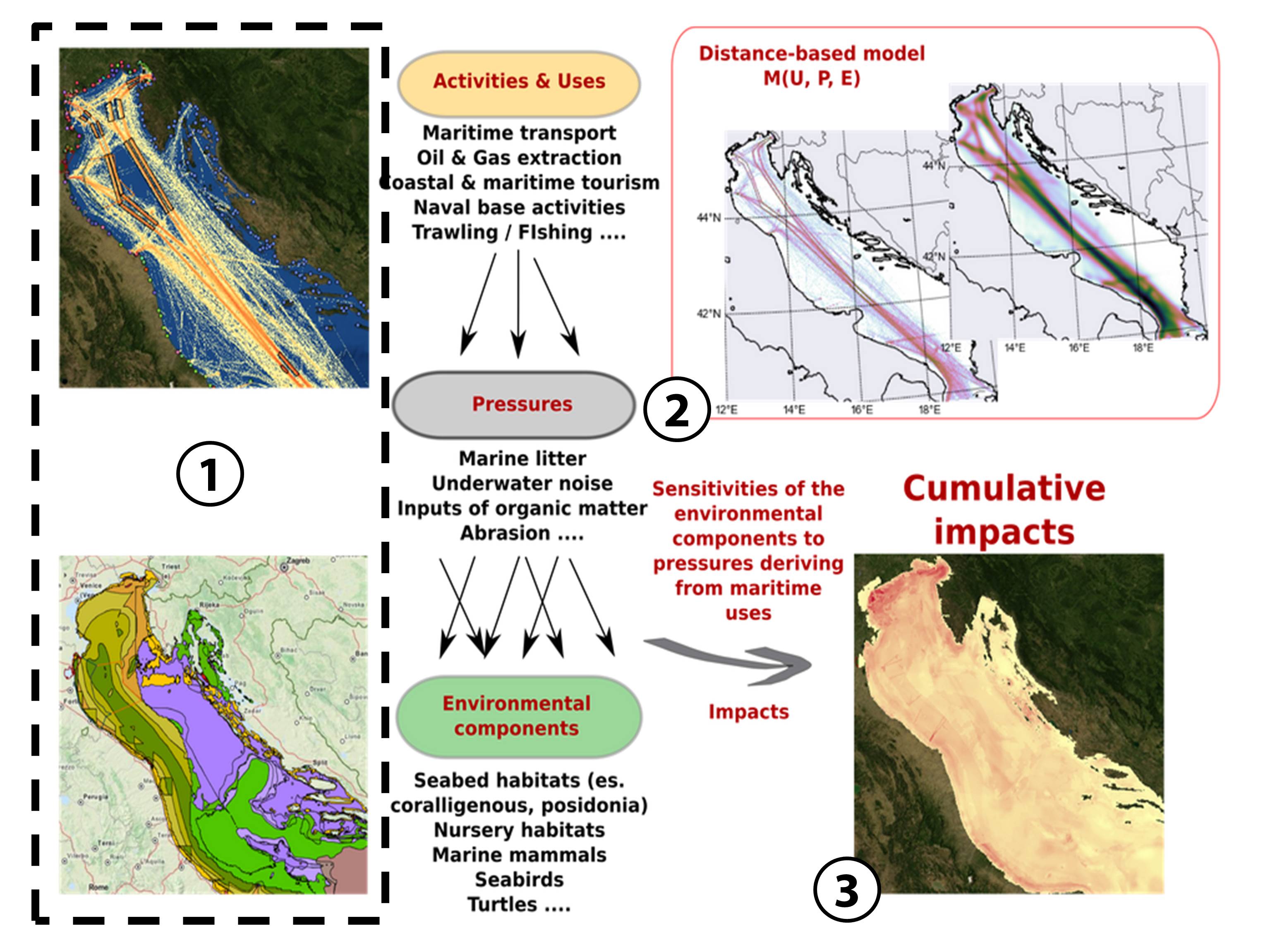
Figure 1. Stepwise methodological approach for the Cumulative Impact Assesment.
Methodology
CI assessment in the Adriatic-Ionian sub-basin In contrast to Halpern 2008, who considered generic drivers of change, the CI assessment available in the Tools4MSP library considers human use specific pressures on environmental components (marine litter; underwater noise; input of organic matter, abrasion; etc…). Anthropogenic pressures are factors causing temporary or permanent disturbances or damage to one or several components of an ecosystem (MSFD 2008/56/EC). The CI tool implements pressures as the conversion factor between human activities and potential environmental impacts. The CI spatial model implemented can take into account the dispersion of the pressure generated by each single human use in form of a buffer distance. The stepwise methodology implemented for the CI assessment tool can be described as follows (Figure 1):
- Step 1:
- Collection of geospatial datasets on human activities (maritime transport; oil & gas extraction; coastal and maritime tourism; naval base activities; trawling/fishing; etc…) and environmental components (seabed habitats; nursery areas; marine mammals; seabirds; turtles). Each layer has been spatially normalized using the regular spatial grid (1km2 resolution) of the European Environmental Agency Reference Grid (EEA, 2012).
- Step 2:
- Expert-based analysis of sensitivity scores by associating a pressure (P) generated by human use (U) to the target environmental component (E) by considering impact extent, impact level and recovery time, buffer area. Each expert assessed also the confidence level c(U,P,E) as the level of reliability of their judgments based on empirical evidences, literature or personal knowledge.
- Step 3:
- Computation and visualization of geospatial results of the CI assessment.
Outputs
The main outputs of the tool are the following:- Cumulative impact maps.
- Sea use overlay analysis maps.
- Generation of statistical outputs on impact scores (plots and tables) for single sea uses and environmental components.
- Analysis of gaps in terms of data availability and input data based on data availability maps and statistical outputs.
Any question?
Tools 4 MSP groupCNR - Institute of Marine Sciences
Email: tools4msp[at]ismar.cnr.it